Wildfires, Sundowner Winds, and Santa Barbara County
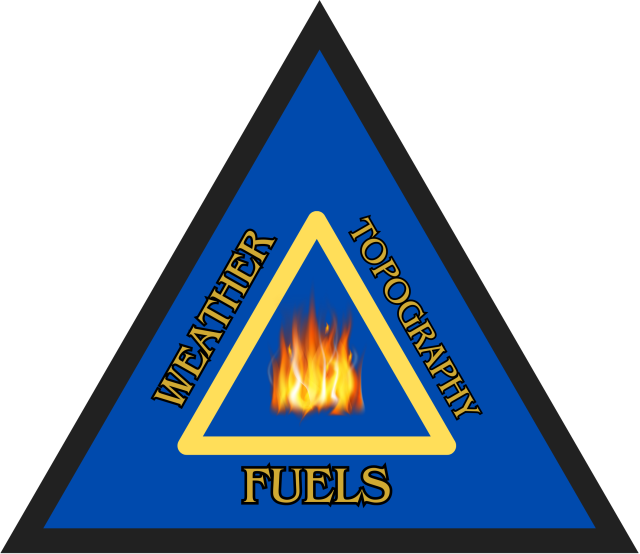
Wildfire behavior in an environment is linked to three interconnected pillars: weather, fuels and topography. Together, these factors comprise the Fire Behavior Triangle, which describes the primary variables responsible for controlling wildfire growth and movement.
Understanding past, present, and future weather conditions in regions prone to wildfires is essential to protect communities and prevent major disasters. In particular, investigating local patterns of winds, temperatures, and moisture is crucial, as wildfires burn more intensely and with greater vigor under windy, hot, and dry conditions.
The southern portion of coastal Santa Barbara County, encompassing communities such as Montecito, Santa Barbara, Goleta, Isla Vista, and the Gaviota Coast, is bordered by the Santa Ynez Mountains to the north and the Pacific Ocean to the south. Further upstream of this area, one can find the San Rafael Mountains and Santa Ynez Valley. While undeniably picturesque, these geographic features influence regional weather phenomena, including the development of powerful downslope windstorms known as Sundowner Winds (or Sundowners). Named for their typical onset near sunset, these gusty and dry winds descend the southern slopes of the Santa Ynez Mountains, impacting many communities along the slopes, foothills, and coastal areas of Santa Barbara County.
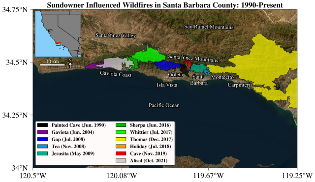
Sundowners have fanned and intensified many destructive wildfires that have affected the region and are considered by the National Weather Service as the most relevant “fire weather” condition in Santa Barbara. Although they occur year-round, Sundowners are most frequent during spring. These winds exhibit significant variability in time and space along the Santa Ynez Mountains, posing a considerable challenge for accurate forecasting and the appropriate placement of firefighting resources.
Understanding Sundowner Winds Using Weather Observations and Models
WRI researchers have investigated Sundowner mechanisms and variability by examining observational data and regional weather model simulations.
The researchers utilized a suite of comprehensive and sophisticated weather data collected during the Sundowner Wind Experiment (SWEX), a regional meteorological field campaign conducted across Santa Barbara county from April 1 to May 15, 2022, to understand features of one particular type of Sundowner that affects the eastern Santa Ynez Mountains (known as Eastern Sundowners), which includes communities living in Santa Barbara and Montecito.
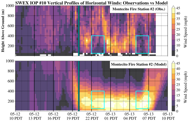
Observations taken from a wind profiler deployed at Montecito Fire Station #2 on May 12-13, 2022, revealed highly erratic wind behavior during the evening hours, with winds near ground level periodically increasing to speeds of 25-40+ mph and then periodically decreasing to speeds below 10 mph (see figure, top panel). The researchers found that these near-surface wind speed fluctuations are likely driven by the formation of “mountain waves”, which are an atmospheric phenomena that occur when strong winds flow over a mountain, generating a wave in the air downstream of the mountain barrier. In the case of the Santa Ynez Mountains, these atmospheric waves cause winds to accelerate as they flow downslope towards the coast, creating intense turbulence that can intensify fire behavior and transport embers well ahead of advancing fire.
Additionally, this work assessed the ability of a regional atmospheric model routinely used in weather forecasts to realistically simulate this observed wind behavior. While the model successfully captured the onset and maximum intensity of the winds, it overestimated their duration and failed to accurately represent the observed variability (see figure, bottom panel). This discrepancy underscores the limitation of numerical models in realistically simulating mountain waves and their interactions with the surrounding environment. Integrating artificial intelligence, additional observational data, and new models could represent a significant step forward in improving the accuracy of forecasts for these events.
Regional Importance and Broader Impacts
This study marks the first detailed investigation of mountain wave behavior in Santa Barbara and was conducted in close collaboration with the regional National Weather Service Los Angeles/Oxnard office, the official agency responsible for local weather forecasting and for issuing Red Flag and Particularly Dangerous Situation (PDS) warnings for Santa Barbara County. Timely and accurate forecasts of Sundowners are crucial for strengthening resilience to wildfires, enabling fire agencies to strategically allocate resources and personnel to high-risk areas during extreme wildfire events.
WRI researchers have a long history of collaborating with the National Weather Service. Findings from this research have been shared with forecasters, and new analytical tools have been developed to assist with the forecast of critical fire weather in Santa Barbara. We are committed to transferring knowledge through co-authored publications with National Weather Service meteorologists and by providing products and training to forecasters and students. These efforts are critical for bridging the gap between science and operations and for effectively preventing fire-related disasters in Southern California.
References
de Orla-Barile, M., Carvalho, L., Duine, G.-J., Jones, C., De Wekker, S. F. J., Harindra, F. J. S., Modjeski, G., Clements, C., Seto, D., Brown, W., Gomberg, D., Kittel, R., Murray, A. T., Exploring the Spatiotemporal Variability of Downslope Winds in Coastal Santa Barbara: Insights from the Sundowner Winds Experiment. Draft manuscript.
Background Information
- Carvalho, L. M., Duine, G. J., Clements, C., De Wekker, S. F., Fernando, H. J., Fitzjarrald, D. R., Fovell, R. G., Jones, C., Wang, Z., White, L., Bucholtz, A., Brewer, M. J., Brown, W., Burkhart, M., Creegan, E., Deng, M., de Orla-Barile, M., Emmitt, D., Greco. S., Hock, T., Kasic, J., Malarkey, K., Modjeski, G., Oncley, S., Rockwell, A., Seto, D., Thompson, C., & Vömel, H. (2024). The Sundowner winds experiment (SWEX) in Santa Barbara, California: Advancing understanding and predictability of downslope windstorms in coastal environments. Bulletin of the American Meteorological Society, 105(3), E532-E558.
- Jones, C., Carvalho, L. M. V., Duine, G.-J., & Zigner, K. (2021). Climatology of Sundowner winds in coastal Santa Barbara, California, based on 30 yr high resolution WRF downscaling. Atmospheric Research, 249, 105305.
- Ryan, G. (1996). Downslope Winds of Santa Barbara, California. National Oceanic and Atmospheric Administration.
- U.S National Park Service. (2017). Wildland Fire Behavior.
Contact