Importance of Hydrant Accessibility
In fire emergencies, the availability of water can be the difference between minimal damage and devastating loss. In 2022, there were 1,504,500 structure fires reported, resulting in 3,790 deaths and some $18 billion in property loss. Fire departments responded to a structural fire, on average, every minute. These incidents highlight the critical role of fire hydrants in emergency response, making hydrant location crucial. In California, standards dictate that hydrants be within 500 ft of residential structures, 300 ft of commercial buildings, and 1,000 ft in undeveloped areas.
Obstacles such as walls, fences, and other barriers can, however, complicate the path from a hydrant to a building. WRI researchers explored hydrant accessibility in Santa Barbara neighborhoods.
City of Santa Barbara Fire Code (2024) specifies that:
- 507.5.1 Where Required, Commercial: A commercial hydrant to Santa Barbara City standards must be located within 300 feet of all portions of a facility or building as measured by an approved route around the exterior of the facility or building …
- 507.5.1.1 Where Required, Residential: For Group R-3, Group U and Group R-2 occupancies containing 10 or less dwelling units, a residential hydrant to Santa Barbara City standards must be located within 500 feet of all portions of a facility or building as measured by an approved route around the exterior of the facility or building …
Assessing Structure to Hydrant Access in Santa Barbara
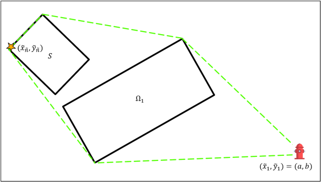
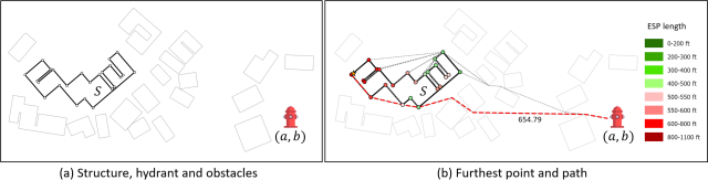
Assessing the relationship between hydrants and structures can be complex. Traditional methods often overlook obstacles such as fences, walls, and other barriers obstructing firefighter access. To address this, WRI researchers have developed a comprehensive GIS-based methodology. This approach derives the distance from a hydrant to the furthest point around a building's exterior while also considering all associated obstacles. The approach provides an accurate assessment of hydrant accessibility, supports risk assessment, and enables fire code compliance evaluation.
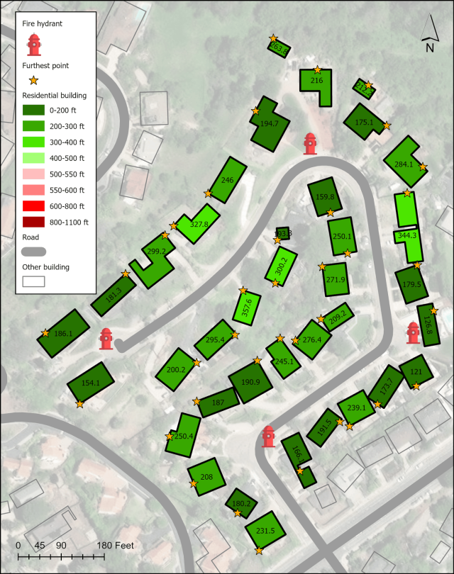
An interactive map of the results for the 21,036 structures across 20,571 parcels in Santa Barbara in terms of proximity to their closest hydrant (out of 2,407 existing hydrants) is linked under the Products tab, and directly accessed here or within the integrated risk and vulnerability layers interface.
What the Data Reveals and Why It Matters
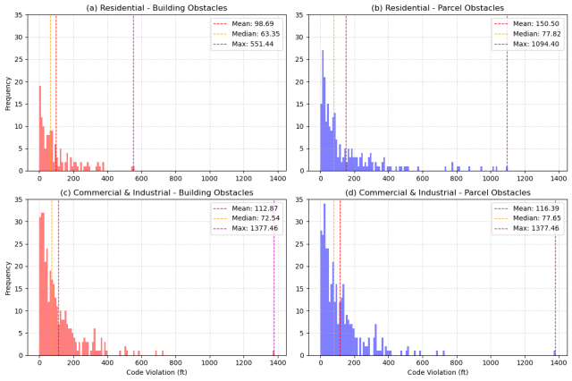
The WRI findings indicate a mixed level of compliance with hydrant access standards. While residential areas generally meet the 500 ft requirement, 36.47% of commercial and industrial buildings do not comply with the 300 ft standard. This hydrant access gap could pose significant challenges during fire emergencies, particularly in more densely built commercial zones. The advanced GIS framework and supporting spatial analytics used in this study have important implications for urban planning and public safety. By identifying areas where hydrant accessibility may be deficient, planners and emergency responders can take proactive measures to mitigate risks.
References
Baik, J., & Murray, A. T. (2024). Emergency Response Planning: A Framework to Assess Hydrant–Structure Access. Transactions in GIS, 28(7), 2412-2424.
Baik, J., & Murray, A. T. (2025). Maximum unobstructed shortest path between multipart-continuous geometries: Enabling novel type of access evaluations for urban safety. Computers, Environment and Urban Systems, 121, 102308.
Contacts